
Land, Lots and Lore: Cadastral Maps Through Time | Scanned Maps | Map Library | MSU Libraries
Land, Lots and Lore: Cadastral Maps Through Time
Maps that mark the boundaries of real property are known as cadastral maps. This exhibit presents several examples of manuscript cadastral maps, historical plat maps, and contemporary GIS-based cadastral resources, showing various methods of presenting property information over time. While cadastral maps are typically created for specific administrative purposes, not all are published for general distribution. Historical cadastral information is valuable to researchers studying historical land use, property law, natural resources, rural sociology, genealogy, and any topic involving the history of land around the world.
This website reproduces a variety of maps from the MSU Map Library Collection including manuscript maps and items published on paper and on the Internet.
| Image | Description |
|---|---|
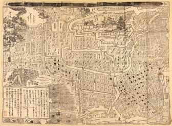 武州豐島郡江戶庄図. Bushū Toshima-gun Edo-shō zu. [Place of publication not identified]: [publisher not identified], 1682. 470-d E-[1631] (Links out to the image at the Library of Congress website) |
Cadastral maps have been used to record property boundaries and land ownership for hundreds of years, and in all parts of the world. This map is a digital reproduction of a 1682 reprint of a 1630-31 map showing land ownership in central Tokyo. The print original is in the collection of the Library of Congress; a high-resolution reproduction is available via the MSU Libraries catalog. Downloaded and printed from the Library of Congress, http://hdl.loc.gov/loc.gmd/g7964t.ct002119. |
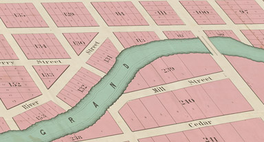
 Opens in a New Tab Map of Land in the Eighth Ward of the City of Brooklyn belonging to the heirs of Leffert Bergen. Drawn by [Brooklyn] City Surveyors Ludlaw and Stuchfield in March 1882. 832-d E-1882 (Brooklyn) |
This map is an example of a 19th century property sale map made for a specific auction event; it was mounted on linen and was meant to be rolled and tied. Leffert Bergen’s family was among the original Dutch settlers of a remote place called Breuklen, Nieuw Nederland, later called Brooklyn, New York. For several generations this family worked their own farms. Being close to and later part of New York City, land values rose and land use switched from farmland to commercial and residential use. Leffert Bergen only inherited a sliver of the original family farm, but even so when a portion of his lands were sold off in 1882 (26 years after his death), his sliver had become several extremely valuable city blocks. Almost half of the map is devoted to property below the high tide mark. Though this area is unsuitable for homes or farms, it was much sought after as piers could be built out into the Upper Bay of the Atlantic Ocean to receive ships serving nearby warehouses. This map was a gift of Ron Dietz. |
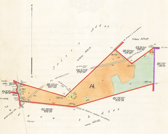 [Plan and Deed of Land owned by Augusts and Tēkle Mālnieks, near Inčeru Sādža, Latvia]. Place and Publisher not identified. 1928. 683-d E-1928 (Inčārnieki) |
This land deed describes a 10 hectare (about 25 acre) farm owned by siblings Augusts and Tēkle Mālnieks located near the village Inčeru Sādža (now called Inčārnieki) in the Madona District of Latvia. The deed was granted in 1928, a period of time when Latvia had achieved independence from Russia but before the Soviet Union regained control 1940. Augusts was granted 4/5th ownership and his sister 1/5th ownership. This map was found at an estate sale in California. It was a gift from Charles Schoenknecht and Ward A. Paul. |
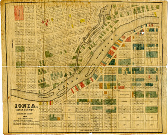 Ionia, Ionia County, Michigan Terr’y. Published by Pendletons Lithography in Boston in 1835, probably for Nathaniel Brown. 843-d E-1835 (Ionia) |
This map shows a thriving town site. The only problem was that it was a complete fiction. The real Ionia Center, Michigan, the seat of Ionia County, already existed two miles to the west of this site. The map carefully details the true physical features of section 21 of current day Ionia Township, however the town lots, the mill race and the mill pond only existed in the mind of the owner. Numerous lots have been color coded to some unknown system. At the time the map was made in 1835, half of the square-mile section had been purchased by Chicago-based land speculator Nathaniel Brown. The other half was still owned by the U.S. government. Brown had the idea of a sawmill anchoring a community that in time could steal the County Seat from nearby Ionia Center (later renamed City of Ionia). Although some lots were sold, the venture came to nothing. About forty years later a small community called Prairie Creek was platted on the north-west corner of the site which today is surrounded by an enlarged City of Ionia.This map was a gift from Ronald Dietz. |
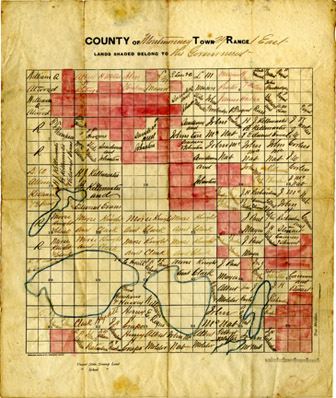
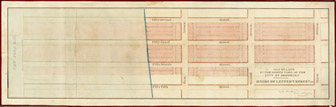
County of Montmorency Town 29 Range 1 East. 843-c E-1874 |
This plat map shows land owners in one 6-mile by 6-mile survey township in Montmorency County, Michigan. The names entered here represent the first time these lands were in private hands under state and federal law and shows transactions that occurred through approximately 1874. Practically all of the land sold in this township served as either bounty lands to compensate veterans under the Scrip Warrant Act of 1855 or to support the establishment of Agricultural Colleges through the Morrill Act of 1862. The proceeds from land sold to John Richardson in sections 13 and 24, for instance, benefited the widow of Private Matthew Alexander who served in the Revolutionary War. Proceeds from the lands labeled ‘Morse Knight and Clark’ in sections 22 and 27 went toward the establishment of The Ohio State University. After this map was made, the town of Lewiston formed on the north shore of East Twin Lake, which was a hub of the lumbering industry for a time. This map was a gift of Ron Dietz. |
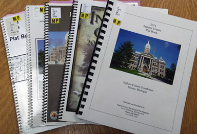
Publishers began creating inexpensive county plats with landowners’ names, available for purchase by the general public. They were so popular with local and regional customers that new plat maps were made for many counties every few years, often sponsored by local 4-H clubs, peaking in the mid-to-late 20th century. Some early plats were made into large wall maps, but over time smaller more easily preserved atlases became the norm. These county plats are most plentiful in the US Midwest, where the geometric lines of the US Public Land Survey System made page-sized township maps relatively easy to produce. Generally only parcels of 10 acres or more show the landowner’s name.
| Image | Description |
|---|---|
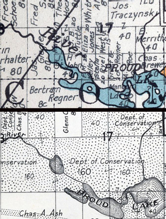
McAlpine's Oakland County Map, Farm Edition. Published in Birmingham, Michigan by Wilbur S. McAlpine, 1921. G1413.O2 M335 1921 McAlpine's Atlas of Oakland County, Michigan. Published in Birmingham, Michigan by Wilbur S. McAlpine Map Co, 1947. G1413.O2 M34 1947 |
These two plat maps of Commerce Township in Oakland County show land use changes between 1921 and 1947. In the 1947 map (right), we see an area that had formerly been privately-owned land now in the hands of the Michigan Department of Conservation. The Proud Lake State Recreation Area, established in 1944, was purchased with funds provided by the Michigan Legislature. By 1947 approximately two-thirds of the intended Proud Lake lands had been acquired. These two atlases were acquired using funds from the Tamara Brunnschweiler Geography Endowment. |
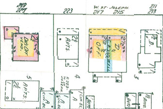 Page 42. Sanborn Map Company. Insurance Maps of Lansing, Michigan. 1953-1956. |
Interstate Highway 496 was built from 1963 to 1970 through the center of Lansing. These two maps show the site of one stretch of the highway before and after it was built. This detailed map shows every building and street of a small part of Lansing. Pink buildings are brick, blue buildings are stone. Changes to the buildings were indicated by pasting small bits of paper over the map, showing changes between 1953 and 1956. |
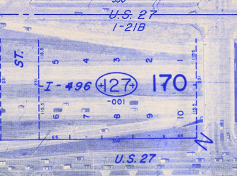 Sheets 1-21B and 1-21C. Ingham County, Michigan. West Chicago, IL: Sidwell Co. 1974. |
This map shows the same exact area as does the Sanborn map above. It is a composite of parts of four sheets used by the Ingham County government to track parcels. The underlying aerial photography was taken in Spring 1974. These maps were a gift from MSU Remote Sensing & GIS. |
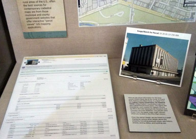
While plat books continue to be published for some rural areas of the U.S., often the best sources for contemporary cadastral information are from those municipal and county government websites that offer interactive “parcel viewer” GIS mapping applications. Here we see parcel information for the long-vacant Citizens Bank site at the corner of Grand River Avenue and Abbot Road in East Lansing, in a detail from the Ingham County Equalization Tax Mapping Viewer.
| Image | Description |
|---|---|
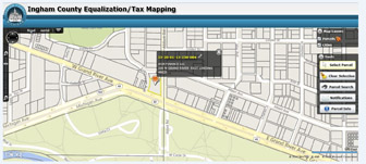 Ingham County Equalization Tax Mapping Viewer |
The digital plat boundaries were created for Ingham County by MSU’s Remote Sensing & GIS Research and Outreach Services (RS&GIS). The parcels were drawn from paper maps which are located in the MSU Map Library. From the parcel viewer, one may link to a page displaying various other details about the property, including assessed values, sale history, photos, zoning status, and building size. From the parcel viewer, one may link to a page displaying various other details about the property, including assessed values, sale history, photos, zoning status, and building size. |
Further Reading:
- The Cadastral Map in the Service of the State: A History of Property Mapping. Written by Roger. J. P. Kain and Elizabeth Baigent. Published in Chicago by the University of Chicago Press in 1992.