
John Farmer, Mapmaker, 1798-1859
John Farmer lived in a time when wide open possibilities were available in a newly settled land and an energetic effective person could be the first in many areas.
Born in Saratoga County upstate New York, he first became a school teacher and taught map drafting among other topics. Michigan Territory was eagerly seeking school teachers. The University of Michigan operated no higher education but was running a primary and secondary school. In December 1821 the board of University of Michigan in Detroit offered him a position as head of the Lancasterian School.

Farmer found additional work hand copying township maps from the freshly-made surveyor’s manuscripts, and sold them to the settlers who were entering the state. He also drew for the Treasurer of the United States a map of Michigan’s first real road, which had been funded by the federal government. He then assisted Orange Risdon in drafting a map of the surveyed part of Michigan. When Risdon’s project stalled, Farmer ended up publishing his own detailed map of the state in 1826.
In the 1830s instead of revising his existing map, he planned and executed a new map containing more much detail. It had so much detail, in fact, that outsourcing the engraving of the map to copper printing plates would have been prohibitively expensive. His son later wrote in a history of the City of Detroit, “He procured a set of engraver’s tools and undertook the work.” This Map of the Surveyed Part of the State of Michigan depicts in great detail the southern half of Michigan’s lower peninsula. At that time Michigan Territory extended far to the west, and map insets showed the Mackinac area, a settlement at what is now Cassville, Wisconsin, and the settlement at what is now Green Bay, Wisconsin.
He also produced regional maps starting in 1835 when both Michigan and Wisconsin were still mere territories, but continuously revising them over the years to reflect changes in development. In 1835 his Michigan & Wisconsin map was titled, Improved Map of the Territories of Michigan and Ouisconsin (Pronounced Wisconsin) on a Scale of 30 Geographical Miles to an Inch. At the time of his death nearly 25 years later he was still producing a Michigan & Wisconsin map, now titled Map of the States of Michigan and Wisconsin, embracing a great part of Iowa and Illinois and the whole mineral region with a chart of the lakes: Exhibiting the sections, the geological formations, and the general topography.
After a few years Farmer sold the publishing rights to his maps to eastern publisher J. H. Colton and turned his attention to mapping new communities and became involved in the formation of a Detroit Board of School Inspectors.
But Farmer saw there still was need for continuously updated maps of the whole state, which was being settled quickly and was continuously seeing formation of new towns, townships, and counties. In 1844 he launched his master work, The State of Michigan and the Surrounding Country. This map contained extreme detail of every surveyed square mile, every stream, swamp, and every road and trail. Michigan residents found it absolutely essential, so much that supply could not keep up with demand. A hot secondary market formed where used copies of Farmer maps sold for much higher than their stated price.
Farmer's method for physical detail was to transfer details from the original surveyor's plat maps available in the U.S. Land Office in Detroit. By the end of the 1850s all of the state had been surveyed into over 2,600 townships and divided into over 61,000 mile sections. Each township was mapped separately on large sheets at large scale noting lakes, swamps, tree and land cover types, and other major features. Farmer reduced all this detail to a single sheet map of the state.
Farmer devoted much time and effort to maintaining the currency of his maps. He closely watched political developments in the state and quickly incorporated the formation of new counties, townships and settlements into his nearly annual revisions. He continued, however, to produce other varied works, including an enormous (over 5 feet by 6 feet, or, 1.6 meters by 1.8 meters) multi-sheet map of Michigan and Wisconsin and surrounding areas.
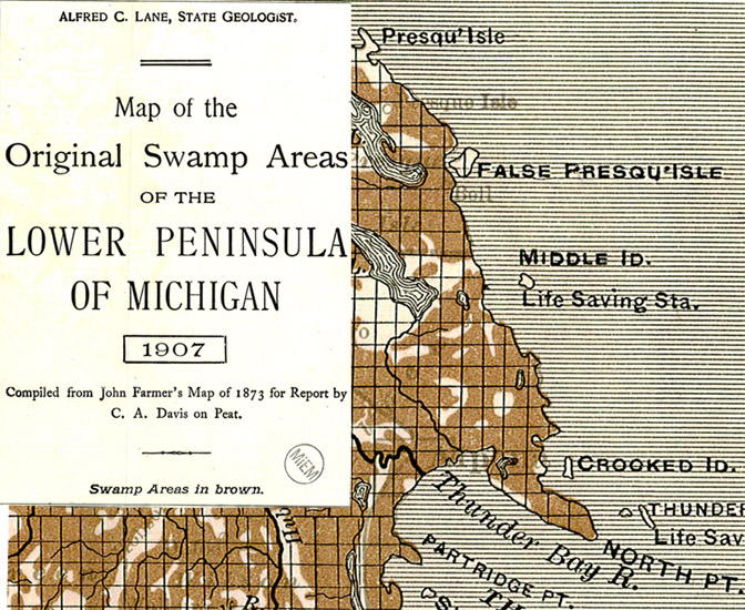
It is said that John Farmer worked himself to death. He worked ceaselessly on projects, issuing his enormously detailed maps as frequently as possible. No other state in the Northwest Territory (or possibly in the entire United States) has such detailed cartographic records of from this time period. Decades later, the Michigan Geological Survey issued a map of Michigan's swamps simply by copying over the detail from Farmer's master work.
Farmer died March 24, 1859 in Detroit, Michigan. His widow Rachel Farmer and sons Silas, Arthur and John carried on the business for some time afterward. Maps published after John Farmer's death, however, never maintained the detail and currency of his former work.
John Farmer Timeline
- March 21, 1821 writes up articles of incorporation for Michigan Territory’s first Methodist Episcopal church
- 1822-1823: Copies surveyor’s plats and sells them by the sheet.
- 1824: Works with Orange Risdon on his map
- 1825: Map of the National Road
- 1825: Map of the Surveyed part of the Territory of Michigan (September)
- 1826: Map of the surveyed part of the Territory of Michigan (December)
- 1829: An improved map of the surveyed part of the territory of Michigan
- 1830: Map of the territories of Michigan and Ouisconsin
- 1830: Emigrants’ Guide, Or Pocket Gazetteer of the Surveyed Part of Michigan (32pp)
- 1830: First issued 'The Emigrant's Guide, or Pocket Gazetteer of the Surveyed Part of Michigan.'
- 1830: Named surveyor for (City of Detroit or the State of Michigan?)
- 1831: Drafted a Map of Detroit to accompany the Governor and Judge’s plan to Congress
- 1831: revised gazetteer issued
- 1833-1835: collected material from around the territory, planned more elaborate map of Michigan
- 1835: Drafted the first map of Detroit which accurately delineated the lot lines
- 1835-1836: Published An improved edition of a map of the surveyed part of the Territory of Michigan.
- 1836: revised gazetteer issued
- 1836: Sold map of Michigan to Colton of NY and published by them for many years.
- April 27, 1837: Lost 3 store buildings to a fire
- 1837: made maps of “innumberable paper cities”
- 1838-?: Served as Detroit City Treasurer
- 1838-1842 School District Chairman of the Board
- 1839-1842: Served as Sealer of Weights and Measures for the City of Detroit
- 1841-1843: Served as the surveyor for the City of Detroit
- 1844: Map of Michigan 12 miles to the inch “gave him a national reputation. No State other than Michigan has had a map comparable with it for completeness” (Silas Farmer, 1890)
- 1839-1842: Sealer of Weights and Measures
- 1840 4th School District Officer
- 1841-1843: City Surveyor
- 1843 Second Ward School Inspector
- 1842: Resolved to collect from the County Treasurer money due from the treasury to support the district library
- 1844: First publishes Map of the State of Michigan and the Surrounding Country
- 1859: John Farmer dies at St. Mary's Hospital in Detroit, Michigan
Sources
- Bibliography of the Printed Maps of Michigan, 1804-1880, With a Series of Over One Hundred Reproductions of Maps Constituting an Historical Atlas of the Great Lakes and Michigan. By Louis Charles Karpinski and William Lee Jenks. Published in Lansing, Mich by the Michigan Historical Commission in 1931.
- The Farmers: Map-Makers and Historians to the City of Detroit. By James M. Babcock. Published in Detroit, Mich by the Burton Historical Collection in September, 1967.
- The First Railroad and Township Map of Michigan. By LeRoy Barnett. Published in Chronicle & Newsletter [Historical Society of Michigan] vol. 25 issue 2 (Summer 2002), pages 7-8.
- Historic Michigan: Land of the Great Lakes. Volume 3. Edited by George B. Catlin. Published in Dayton, OH by National Historical Association, Inc. in 1924.
- The History of Detroit and Michigan, or, The Metropolis Illustrated. A chronological Cyclopaedia of the Past and Present. Second Edition - Revised and Enlarged. By Silas Farmer. Published in Detroit, MI by Silas Farmer in 1889
- History of Detroit and Wayne County and Early Michigan. A Chronological Cyclopedia of the Past and Present. Township and Biographical Edition. By Silas Farmer. Published in Detroit, MI by Silas Farmer in 1890.
- A New Map. Detroit Free Press, May 30, 1849, p. 2.
- Sudden Death of Mr. John Farmer. Detroit Free Press, March 25, 1859, p. 1.
- Tooley’s Dictionary of Mapmakers, Revised edition. By Ronald Tooley. Edited by Josephine French. Published in Riverside, CT in 2001.