
close
Provide feedback on this item
Please provide details, labels, or ideas that will help this image be more findable and better described.

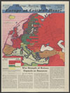
Europe at critical hour
This map of Europe uses color to represent the influences (or lack thereof) of the United Kingdom, France, the Soviet Union, Germany, and Italy over other countries in Africa and Eurasia. The map was drawn in 1938, a year before the start of World War II.
1938-04-10
49 x 36.7 cm
Tribune Company
color
- English
1938
- Coalition (Social sciences)--1930-1940
- International relations--Europe--1930-1940
- War allies--1930-1940
- still image
- text
- These materials are either in the public domain, according to U.S. copyright law, or permission has been obtained from rights owners. The digital version and supplementary materials are available for all educational uses worldwide.
- The Janet A. Ginsburg Chicago Tribune Image Collection
- Chicago Sunday Tribune (April 10, 1938), Graphic Section/Camera News Review, p. 1
- application/pdf
- image/jpeg

- Home
- About
- Full Text Search
- Browse
- Contact Info